Climb Mount Shasta, California
Climb Mount Moriah, Nevada
A four-hour drive from Salt Lake City, Great Basin National Park is a little-known gem where mountains over 13,000 feet rise dramatically from the desert floor. Wheeler Peak (13,063 feet) is the highest mountain in the park, but if you want diversity of terrain, local rangers suggest trekking the 11-mile Hendrys Creek Trail to the summit of 12,067-foot Mt. Moriah. The 5,000-foot vertical climb takes you through thickets of pinon pine and vast glades of aspen forest. At 11,000 feet, you reach the Table, Moriah’s rolling sky-high plateau. On the Table’s rim are stands of twisted bristlecone pines, which, at 3,000 to 4,000 years old, are the oldest type of tree on the planet. From here, it’s just a scramble up rocks to the summit. If visibility is good, you can look across an uninterrupted carpet of sagebrush for a good 100 miles.
Climb Katahdin
The sweltering days of summer is when my mind wanders to the lofty peaks of North America. Unless you like climbing with ice axe and crampons, this is the best time to bag a peak. This week, I’ll be discussing some of my favorite climbs in the States. First stop, mighty Mount Katahdin at Baxter State Park, Maine.
My Favorite Small Outfitters, Ken’s Hinterland Adventure Tours, Dominica
Unlike the rest of the Caribbean, the attraction in Dominica is not the beach, but a lush mountainous interior ripe with every tropical fruit and vegetable imaginable and inundated with so much water that around every bend is another raging waterfall, a serene swimming hole nestled in the thick bush, or a hidden hot spring to rest your weary body after a day in the outdoors. Indeed, this island closest to Martinique has become an affordable haven for the active traveler who yearns to hike through a jungle-like forest. My guide for a week of treks into the interior was Kent Augiste of Ken’s Hinterland Adventure Tours. The highlight was a 7-hour round-trip hike inside Morne Trois Pitons National Park to the crater known as Boiling Lake. We hiked through a dense forest of tall gommier trees, staring at the iridescent purple-throated hummingbirds as they kept us company. Afterwards, we lounged in the natural hot spring at Papillote Wilderness Retreat. Owner Anne Jno Baptiste first came to the island from the States in 1961. Eight years later, she bought a 7-acre chunk of land enveloped by the rainforest that she would cultivate into a flower-rich botanical garden and one of the Caribbean’s first eco-resorts.
My Favorite Small Outfitters, Bob Hicks at Gros Morne Adventures
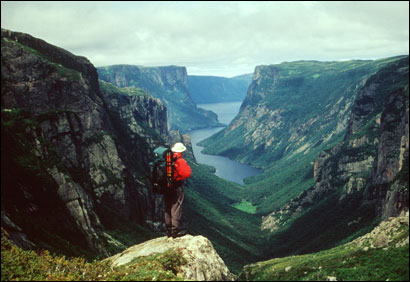
 In the summer of 2002, I had the pleasure of backpacking the stunning Long Range Traverse, on assignment for Backpacker magazine. Nestled within Newfoundland’s Gros Morne National Park, a designated UNESCO World Heritage Site because of its unique combination of quartzite rock and wetland terrain, the Long Range Mountains could very well be the one of the last remnants of pristine wilderness within a three-hour flight of New York and Boston. There were no manicured trails with requisite wooden signs showing us which way to go and exact mileage to get there. The Long Range Traverse is a 35 kilometer semi-circular route where topo maps and a compass are a necessity to find your way among the web of caribou paths. Indeed, caribou and moose far outnumbered the four other backpackers we saw on the four-day traverse, averaging one hiker per day.
Hiking Gulf Hagas from Lodge to Lodge
The people of Maine often refer to Gulf Hagas as the "Grand Canyon" of the state. There’s nothing wrong with a little zealous pride, but Gulf Hagas is no Grand Canyon. However, it is one of Maine’s most spectacular hikes. Hidden amidst the 100 Mile Wilderness of the Appalachian Trail, a 45-minute drive on dirt roads from Greenville, Gulf Hagas is a gorge carved by the pounding waters of the Pleasant River and the lumbermen’s dynamite. A series of exquisite waterfalls await you as the river drops nearly 500 feet in 2.5 miles through the narrow walls of the slate canyon. Buttermilk Falls is an apt name for the frothy white foam the water becomes as it churns down the rocks. A swimming hole just beyond the falls is a favorite place for hikers to strip down to their undergarments and plunge into the auburn-red waters. Those piercing screams heard are just folks getting used to the cool temperature.
Kudos to Kyle Maynard
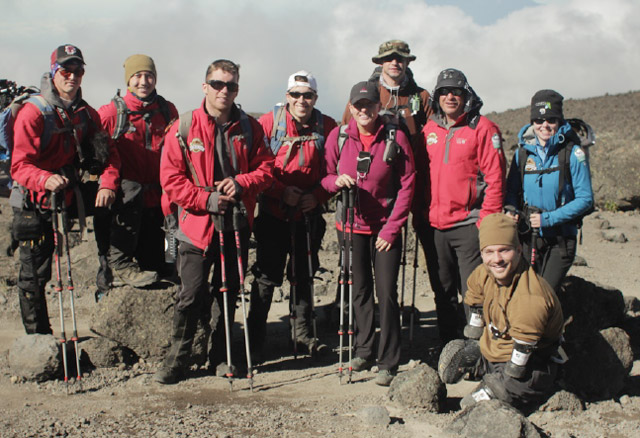
 I was working out at the gym last Sunday watching SportsCenter on ESPN, when they featured a fascinating profile of quadriplegic Kyle Maynard. Maynard, 25, was born with arms that end at the elbows and legs that end at the knees. But that never stopped him from doing a damn thing, including wrestling in high school. Thus his motto, “No Excuses.” Several months ago, Maynard raised the stakes when he attempted to climb 19,340-foot Mount Kilimanjaro without prosthetics. Joined by injured American veterans Chris Hadsall and Sandra Ambotaite, Maynard was hoping to raise awareness to the alarming statistic that 18 US Veterans commit suicide every day. After ten grueling days of climbing on all fours over boulders, through snowfields, and avoiding rockslides, Maynard and his team made it to the summit on the morning of January 15th. That should motivate you to go outside and do something active this weekend. If not, you can always hire Maynard, a motivational speaker, to inspire you.
This Summer, Consider Hiking New Hampshire’s Cohos Trail
My Favorite Fall Foliage Travels—Sleeping Bear Dunes National Lakeshore, Empire, Michigan
Head to the Grand Traverse Bay area, a four-hour drive northwest of Detroit, in the autumn months for a weekend, and you’ll be treated to far more than a fun frolic on a Great Lake. Slow down and explore the region at a slow pace on bike or on two feet and you’ll find diverse terrain, from the shaded wetlands of the Grass River Natural Area to the rolling countryside of the Leelanau Peninsula to the steep dunes of Sleeping Bear Dunes National Lakeshore, the largest sand dunes west of the Sahara Desert. The towering slopes of sand, some as high as 440 feet, slide steeply to the shores of Lake Michigan. Stroll on the 1.5-mile Cottonwood Trail and the dunes look like bowls of sand that only a giant could drink from. No wonder Good Morning America just named Sleeping Dunes the most beautiful locale in America.
